For the best experienceDownload the Mobile App


River Concerns Rise in Northeast Oregon and Naches River Due to Heavy Rainfall ⚠️🌊
Published on: 04/22/2026
This news was posted by Oregon Today News

Description

First Alert Forecast 4-22-26 PM
COPYRIGHT 2026 BY APPLE VALLEY NEWS NOW. ALL RIGHTS RESERVED. THIS MATERIAL MAY NOT BE PUBLISHED, BROADCAST, REWRITTEN OR REDISTRIBUTED.
{
"@context": "https://schema.org",
"@type": "VideoObject",
"name": "River Concerns Rise in Northeast Oregon and Naches River Due to Heavy Rainfall",
"description": "First Alert Forecast 4-22-26 PM COPYRIGHT 2026 BY APPLE VALLEY NEWS NOW. ALL RIGHTS RESERVED. THIS MATERIAL MAY NOT BE PUBLISHED, BROADCAST, REWRITTEN OR REDISTRIBUTED.",
"thumbnailUrl": "https://bloximages.newyork1.vip.townnews.com/applevalleynewsnow.com/content/tncms/assets/v3/editorial/5/95/595e6ed2-8f50-52ff-82f3-68a3ae209f43/69e95599574d5.preview.png",
"uploadDate": "2026-04-22T16:06:00-07:00",
"contentUrl": "https://cdn.field59.com/KVEW/27b9a4846ea6080ef0288baccb236ffc1bb8708a_fl9-720p.mp4"
}
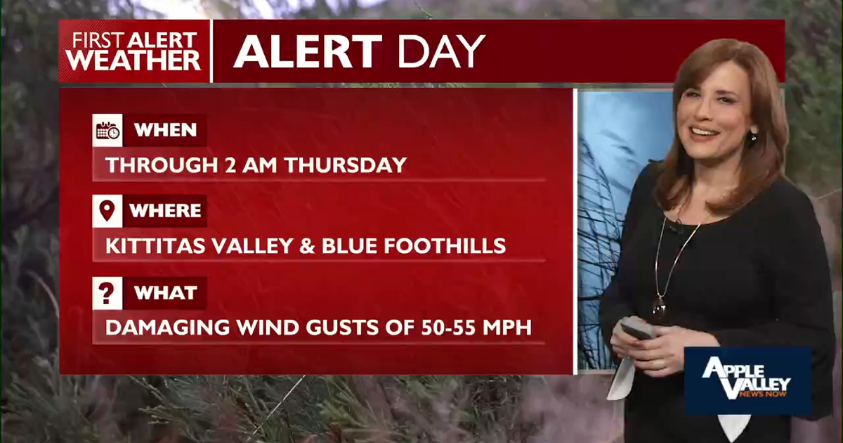
We’re still tracking a band of light to moderate rain sliding across the Columbia Basin and into the Blue Mountains this afternoon and evening 🌦️. It’s not a quick hit either… this system has some staying power, especially along the foothills and higher terrain where the atmosphere is squeezing out every last drop 💧. That upslope flow is doing its thing, and spots like Meacham and Emigrant Springs have already picked up over an inch of rain, with more on the way tonight 📈🌧️.And it’s not just the rain making noise… the wind has been chiming in too 🌬️. Across the Kittitas Valley, gusts have been cranking up into the 40 to 50 mph range, making for a blustery evening commute 🚗💨. Elsewhere, especially along the Oregon foothills and Blue Mountain areas, expect gusts in the 35 to 45 mph range before things gradually settle down later tonight.
Now let’s talk water… because this is where things get a bit more serious ⚠️🌊With steady rainfall adding up, we’re keeping a close eye on rivers in Northeast Oregon, particularly the Umatilla River. Combine that with ongoing concerns along the Naches River, and we’re looking at the potential for rising water levels and localized flooding issues 🚧🌊. Low-lying areas, fields, and spots near riverbanks could see water creeping in, especially if those heavier rainfall totals verify in the Northern Blue Mountains tonight. It’s one of those situations where the ground is already saturated, so it doesn’t take much to tip the balance.
Looking ahead, though, there’s a shift in the script 📖➡️🌤️By Thursday, the atmosphere flips the page to something much calmer. A ridge of high pressure begins to settle in, easing the rain chances and bringing in drier, warmer conditions ☀️. Think of it as the weather finally exhaling after a busy stretch. Into the weekend and early next week, most of the Columbia Basin stays dry, while the mountains may still see a few light showers or even some snow flurries ❄️🏔️, especially toward the Wallowas and higher peaks. But overall, no major systems are lining up behind this one.
🌤️ Quick SummaryRain continues through this evening, heaviest in the Blue Mountains 🌧️Gusty winds gradually easing tonight 🌬️⬇️River concerns developing, especially in Northeast Oregon and along the Naches River ⚠️🌊Turning drier and warmer starting Thursday ☀️📈For the latest river levels, wind updates, and a look at just how warm we get next… be sure to check the Apple Valley News Now Weather App 📱 Your forecast, right in your pocket whenever the sky decides to change its mind 🌦️
COPYRIGHT 2026 BY APPLE VALLEY NEWS NOW. ALL RIGHTS RESERVED. THIS MATERIAL MAY NOT BE PUBLISHED, BROADCAST, REWRITTEN OR REDISTRIBUTED.
Other Related News

04/22/2026
A Houston city ordinance that limited police officers cooperation with federal immigration...

04/22/2026
Navy Secretary John Phelan is leaving his job the Pentagon abruptly announced Wednesday th...

04/22/2026
Oregon football just picked up the biggest addition to its 2027 recruiting class so far
04/22/2026
Dear Annie From the outside my life looks steady and full I have a thoughtful husband grow...
04/22/2026
After three days of drills exercises and an introduction to coach Alex Saramas constraints...
Follow

Download Our App


Copyright 2022 © EPUERTO. All Rights Reserved