

Published on: 03/13/2026
This news was posted by Oregon Today News

Description

Nearly every part of the United States is getting walloped by wild weather or just about to be.
Days of downpours have begun in Hawaii. The Southwest will soon bake with day after day of record 100-degree-plus (38 Celsius-plus) heat. Two storms will dump snow by the foot over northern Great Lakes states. And the dreaded polar vortex will again invade the Midwest and East with soul-crushing Arctic chill.
This forecast of extremes comes as weather whiplash has already hit much of the East. On Wednesday, Washington, D.C., residents walked around in shorts in record-breaking 86 degrees Fahrenheit (about 30 C). On Thursday, it snowed.
“All of the country, even if you’re not necessarily seeing extremes, are going to see generally changing from cold to warm, or warm to cold to warm,” said meteorologist Marc Chenard of the National Weather Service’s Weather Prediction Center in Maryland.
Former National Oceanic and Atmospheric Administration chief scientist Ryan Maue said he expects extreme weather in all 50 states.
Triple-digit heat persists in Southwest
A heat dome will form early next week and park over the Southwest, baking temperatures to triple digits that haven’t been seen this early in the year, Maue and Chenard said.
Some forecasts see 98 F (almost 37 C) in Phoenix on Tuesday, followed by 103, 105 and two days of 107 (almost 42 C). In 137 years of record-keeping, Phoenix never hit 100 before March 26 and usually hit its first 100-degree day in early May, according to the weather service, which warned: “Since we are not acclimated to this level of heat this early in the year, it will be more impactful than usual.”
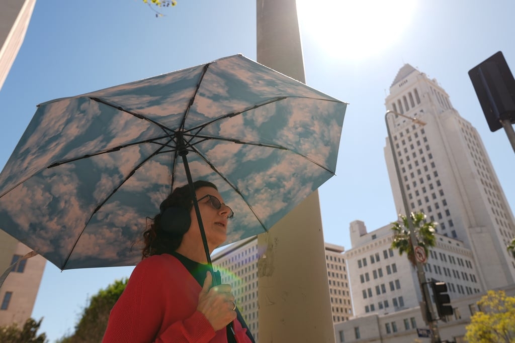
It has already started in Los Angeles, with unusual 90-degree March weather that had people in shorts and tank tops seeking shade wherever they could find it, even if it was as slender as a light post.
Shane Dixon, 40, usually runs about 5 miles (8.05 kilometers) near his home in Culver City without much effort, he said, his face glistening with sweat and his T-shirt tucked into his shorts. But Thursday was hard because of the heat, and he had to cut it short.
“The back of my neck was melting,” he said. But he preferred it to the cold and snow that will hit elsewhere.
“I could go literally soak myself and walk out in the sun, and I’ll make it home fine. If it was freezing cold, I could not do this,” he said.
Single-digit cold invades North
Around the same time as the heat starts blasting Phoenix, the polar vortex — a system that usually keeps frigid air penned up near the North Pole — is forecast to send its chill deep into the Midwest and East, even bordering some of the Southeast, Maue said.
Minneapolis will hover around zero (-18 C) for a low, and Chicago will be in the single digits Tuesday. The next day, “temperatures in the teens and 20s in the Northeast and 20s in the Mid-Atlantic,” Maue said. Even Atlanta could drop to the 20s.
One-two snowstorm punch
Two storm systems in a row — one Friday, then another Sunday into Monday — will chug along the country’s northern tier and Great Lakes and between them could dump 3 to 4 feet (0.91 to 1.22 meters) of snow in places, Maue said.
That bigger second storm system will see its barometric pressure drop so quickly and sharply — meaning it is intensifying and winds are strengthening — that it will qualify as a bomb cyclone, which is quite unusual to develop over land. Normally, bomb cyclones get their energy from warm ocean waters, but this one will draw from the polar vortex.
Just south of the area in Michigan where the heavy snow will hit, there’s potential for a significant ice storm, said meteorologist Jeff Masters with Yale Climate Connections.
Big winds are coming to Texas
An area stretching from Kansas south through Oklahoma and cutting through to Texas to the Gulf of Mexico is forecast to get high winds in the 60 mph (97 kph) range with gusts a bit higher Sunday night, Masters said.
San Antonio and Austin are in the high wind area, and places where there hasn’t been a lot of rain will have a heightened wildfire risk, Masters said.
Even Alaska and Hawaii aren’t quite right
Maue said Hawaii is getting an atmospheric river with such persistent heavy rain that flooding will be a major issue. Oahu is under a flash flood warning.
And Alaska is normally frigid now, but it will be about 30 degrees colder than usual, he said.
It is “the time of year where we can see stuff like this,” Chenard said. “But this does seem even anomalous from what you would typically see. I mean, some of these areas will be setting records. Record-high temperatures for March and maybe multiple times.”
In the past week or so, tornadoes have killed at least eight people in Oklahoma, Michigan and Indiana. The forecast for severe storms doesn’t look as big or widespread for the next week, but dangerous thunderstorms could pop up “anywhere from the Mississippi Valley toward the East Coast” on Sunday or Monday, Chenard said.
The jet stream goes nuts
Underlying this is a jet stream gone wild, Maue and Chenard said.
The jet stream is the river of air that moves weather from west to east on a roller coaster-like path. Usually, the plunges are as mild as a kiddie roller coaster. But now that jet stream is barreling down near-vertical, scream-inducing drops, followed by straight-up ascents.
“Which means you get a lot of extremes next to each other,” Maue said. Storm fronts coming from the Pacific hit that high pressure heat dome in the Southwest and are pushed north to climb that mountainous jet stream peak, “grab access to that cold air reservoir up there” and bring it back down south down the other side of the hill, he said.
Numerous studies have connected unusual jet stream and polar vortex activity to shrinking Arctic sea ice and human-caused climate change.
But there is hope.
“The first day of spring is 20th (of March), and then after that we get recovery,” Maue said.
___
Associated Press writer Dorany Pineda contributed from Los Angeles.
___
The Associated Press’ climate and environmental coverage receives financial support from multiple private foundations. AP is solely responsible for all content. Find AP’s standards for working with philanthropies, a list of supporters and funded coverage areas at AP.org.
News Source : https://www.opb.org/article/2026/03/13/us-forecasts-blizzard-polar-vortex-heat-dome-and-atmospheric-river-all-at-once/
Other Related News

03/13/2026
No other city beats our community spiritPhotos from Albany Public Librarys post

03/13/2026
Tolowa Dee-ni NationThe community is invited to a community design meeting to help the Nat...
03/13/2026
Portland resident Kelli Caldwells mother suffers from severe mental illness and episodes o...
Follow

Download Our App


Copyright 2022 © EPUERTO. All Rights Reserved